A concise history of Tuttle, Oklahoma
Researched and written by Kenneth Bomgardner for the Tuttle Historical Society, August 17, 2026
This report is a detailed, multi-chapter history of the flags, sovereign powers, and historical eras that have claimed jurisdiction over the region of modern-day Tuttle, Oklahoma, from pre-Columbian times to statehood and beyond. There are conflicting written accounts of the history of this area. We invite your comments, if you believe anything in this history that should be different than shown.
1. Pre-Columbian Native Americans: Sovereignty Before the Cloth Banner
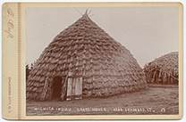
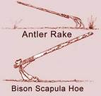
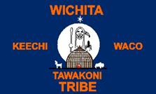
Long before European explorers brought woven banners to the North American continent, the fertile floodplains and prairie terraces along the South Canadian River—where Tuttle sits today—were home to sophisticated Indigenous civilizations. During the Archaic and Woodland periods, early hunter-gatherers tracked bison, deer, and small game across central Oklahoma, utilizing the river valley’s timber and natural springs. By the Plains Village period (circa 1000–1500 AD), ancestors of the Caddoan-speaking peoples, particularly the Wichita and affiliated tribes, established permanent agricultural settlements in the region. These early Oklahomans cultivated maize, beans, and squash in the rich bottomland soils while conducting seasonal hunts across the open plains.
Though these ancient societies did not fly cloth flags in the European tradition, their territorial sovereignty, tribal governance, and spiritual authority were clearly proclaimed through sacred heraldry and cultural symbols. Autonomous domains were demarcated through painted bison robes, carved ceremonial pipes, elaborate feather-work banners, and distinctive pottery styles that identified specific kin networks and village confederacies. Tribal emblems mounted on staff poles signaled leadership, peace delegations, or war readiness to neighboring groups.
Trading networks extended across the continent, connecting the residents of central Oklahoma to the Mississippian mound centers to the east and the Puebloan societies to the west. The South Canadian River served as both a vital highway and a natural boundary, around which communities maintained law, resource management, and diplomatic relations. For centuries, these Indigenous symbols represented the undisputed, original sovereignty over the soil that would much later become Grady County.

2. The Spanish Empire: The Cross of Burgundy over the Southern Plains (1541–1800)
European claims to the central plains began in 1541 when Spanish conquistador Francisco Vásquez de Coronado marched north from New Spain in search of the mythic, gold-laden Seven Cities of Cíbola and the wealthy province of Quivira. Crossing the high plains of Texas and Oklahoma, Coronado’s expedition traversed the open prairies near the South Canadian River. Decades later, in 1601, Juan de Oñate, the Governor of New Mexico, led another major Spanish expedition across central Oklahoma, attempting to establish trade routes and solidify imperial dominion over the Southern Plains.
Through these expeditions, the Spanish Crown laid claim to a vast territory that included present-day Oklahoma, incorporating it theoretically into the Viceroyalty of New Spain. The official flag representing Spanish imperial authority during this era was the Cross of Burgundy (Cruz de Borgoña). Featuring a jagged, red saw-toothed saltire cross set against a white field, this flag flew over Spanish garrisons, missions, and colonial outposts across the Americas. It symbolized the power of the Spanish monarchy and the Roman Catholic Church.
Although Spain claimed nominal sovereignty over central Oklahoma for over two centuries, its physical presence near Tuttle remained largely limited to sporadic military patrols, missionary journeys, and trade expeditions operating out of Santa Fe and Texas. The local Wichita, Comanche, and Kiowa nations maintained practical control on the ground. Nonetheless, under international law of the era, the Cross of Burgundy was the first official European banner to cast its shadow across the red dirt of Grady County. Spain’s legal claim persisted until diplomatic maneuvering in Europe transferred the territory to France at the turn of the 19th century.
3. The French Republic & Royal France: The Fleurs-de-lis and the Tricolor (1682–1803)
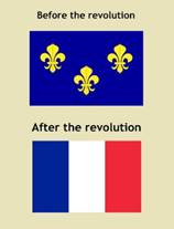
French interest in the region began in earnest in 1682 when René-Robert Cavelier, Sieur de La Salle, navigated the Mississippi River and claimed the entire Mississippi watershed for King Louis XIV, naming the vast expanse “Louisiane.” French fur trappers, traders, and coureurs des bois quickly pushed westward along the river networks. In 1719, Jean-Baptiste Bénard de La Harpe explored central Oklahoma, establishing diplomatic trade alliances with the Wichita villages along the South Canadian and Arkansas rivers. During this early period, the white royal banner of the Kingdom of France, adorned with golden fleurs-de-lis, represented French territorial ambitions across the interior of North America.
French traders integrated smoothly into the region by trading firearms, metal cookware, and cloth for bison hides and beaver pelts. Unlike the Spanish, who sought conquest and religious conversion, the French focused on commercial partnerships, establishing trade routes that ran through central Oklahoma connecting New Orleans and St. Louis with the western plains.
In 1763, following defeat in the Seven Years’ War, France ceded Louisiana to Spain. However, in 1800, Napoleon Bonaparte secretly reacquired the vast Louisiana territory from Spain through the Treaty of San Ildefonso. For three short years, the official sovereign banner over the region became the French Tricolor—the revolutionary blue, white, and red vertical stripes. Though Napoleon envisioned a revived French empire in the New World, military setbacks in Saint-Domingue (Haiti) and looming war with Great Britain forced a dramatic change of course. In 1803, Napoleon sold the entirety of French Louisiana to the United States, bringing French sovereign claims over Oklahoma to a sudden end.

4. The United States & The Louisiana Purchase: Stars and Stripes Arrive (1803)
On December 20, 1803, the official transfer of the Louisiana Purchase took place in New Orleans, overnight doubling the geographic size of the United States. For the first time, the area that would become Tuttle, Oklahoma, fell under the authority of the American Republic. The flag raised over this newly acquired frontier was the 17-Star, 17-Stripes U.S. Flag, reflecting the recent admission of Ohio to the Union.
To map and evaluate this vast new acquisition, President Thomas Jefferson dispatched military and scientific expeditions into the Southwest. In 1806, the expedition of Captain Richard Sparks attempted to explore up the Red River, while Lieutenant James B. Wilkinson navigated the Arkansas basin. Later, in 1820, Major Stephen H. Long led an expedition down the South Canadian River, passing directly through the area of modern Grady County. Long famously labeled the region part of the “Great American Desert,” asserting that the treeless prairies were unsuitable for European-style agriculture—an assessment that delayed immediate white civilian settlement but made the land an ideal location for the federal government’s planned Indian Removal policies.
During the early decades of American administration, the United States military established forts along the perimeter of Indian Territory—such as Fort Gibson and Fort Towson—to enforce federal authority, map wagon trails, and manage relations between western indigenous tribes and incoming relocated nations. The American flag during this era symbolized distant federal oversight, military protection, and the precursor to sweeping demographic changes across the Southern Plains.
5. The Choctaw Nation: Sovereign Tribal Lands on the Trail of Tears (1820–1855)
In the 1820s and 1830s, the United States government initiated a systematic policy of forcibly removing Southeastern Native American nations from their ancestral homelands to lands west of the Mississippi River. Through the Treaty of Doak’s Stand (1820) and the Treaty of Dancing Rabbit Creek (1830), the Choctaw Nation ceded millions of acres in Mississippi in exchange for a massive reservation in Indian Territory that stretched across southern and central Oklahoma, encompassing the area near modern-day Tuttle.
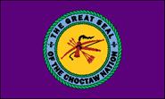
Upon arrival along the Trail of Tears, The Choctaw Nation established a constitutional government, a written judicial system, schools, and legislative councils. The Choctaw Nation Flag featured a deep purple-blue field framed by a red border, centered around a circular seal. Within the seal sat an unstrung bow, three arrows, and a pipe of peace (calumet), representing military strength, peace, and tribal governance.
During the period from 1830 to 1855, the land around Tuttle was under the legal jurisdiction of the Choctaw Nation. Choctaw families established farms, ranches, and trade networks throughout the territory. The Choctaw government managed law enforcement and land usage, granting grazing leases to cattlemen and regulating passage through their sovereign lands. This period marked a crucial era of nation-building, where tribal constitutional governance replaced federal military administration, establishing a structured society on the Oklahoma prairie.
6. The Chickasaw Nation: Pickens County and Tribal Autonomy (1855–1906)
When the Chickasaw people were forcibly removed from their Mississippi and Alabama homelands in the late 1830s, they initially settled within the boundaries of the Choctaw Nation under the Treaty of Doaksville (1837). However, as a distinct culture with their own leaders and political needs, the Chickasaw sought independence from Choctaw governance. In 1855, a treaty between the United States, the Choctaw, and the Chickasaw formally partitioned the land, establishing a distinct, independent Chickasaw Nation in south-central Oklahoma.
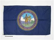
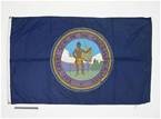
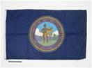
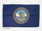
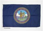
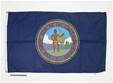
Under this treaty, the location of present-day Tuttle fell inside Pickens County, the northernmost district of the Chickasaw Nation. The Chickasaw Nation Flag flew proudly over the region. The flag features a vibrant blue field centered on the Great Seal of the Chickasaw Nation, depicting the heroic figure of Chief Tishomingo standing with a spear and shield, framed by a golden halo and red border.
The Chickasaw established a prosperous constitutional republic with its capital at Tishomingo. In Pickens County, tribal members developed extensive cattle ranches and agricultural operations, utilizing the rich bottomlands of the South Canadian River. Prominent Chickasaw and Choctaw families, including the Colbert family, from whom land for the Tuttle townsite was later acquired, held substantial property and political influence. The Chickasaw Nation exercised full legal authority over its citizens, court systems, and land management in the Tuttle area for over half a century until federal allotment policies altered tribal land structures at the start of the 20th century.
7. The Civil War & The Confederacy: The Battle for Indian Territory (1861–1865)
At the outbreak of the American Civil War in 1861, the United States military withdrew its troops from outposts in Indian Territory, leaving the Choctaw and Chickasaw Nations isolated and vulnerable to Confederate pressure. Because both nations held deep cultural and economic ties to the South and felt abandoned by the federal government, the Chickasaw and Choctaw legislative councils passed formal resolutions allying themselves with the Confederate States of America in the summer of 1861.
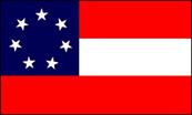
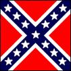
During the war, the Confederate First National Flag (the “Stars and Bars”), as well as the Confederate Battle Flag and tribal military banners, flew over central Oklahoma. Tribal leaders formed military units, such as the First Regiment of Choctaw and Chickasaw Mounted Rifles under the command of Colonel Douglas H. Cooper.
The region around Tuttle became a strategically significant transit corridor. Confederate forces and allied tribal cavalry patrolled the South Canadian River basin to protect the northern border of the Chickasaw Nation from Union raids originating in Kansas. The land served as a vital staging ground for moving cattle, horses, and military supplies to support Southern armies. The devastating conflict left ranches destroyed and internal politics divided. Following the Confederacy’s collapse in 1865, Reconstruction Treaties in 1866 forced the Chickasaw and Choctaw to re-establish allegiance to the United States and grant rights-of-way for future transcontinental wagon roads and railroads.

8. Wagon Roads West: Overland Trails & Military Passages (1850s–1880s)
Following the Gold Rush of 1849 and the expansion of western military posts, central Oklahoma became a key crossroads for overland transportation. Government surveyors, military escorts, and civilian emigrants blazed major wagon roads across the Chickasaw Nation, passing near present-day Tuttle. Among the most prominent routes was the California Road, surveyed by Captain Randolph B. Marcy in 1849, which followed the South Canadian River valley as a safe overland passage to Santa Fe and California.
During this era, the 31-Star to 38-Star United States Flags represented federal oversight along these wagon corridors. U.S. Army cavalry units from Fort Arbuckle and Fort Sill regularly patrolled the wagon roads to protect freight trains, mail couriers, and emigrant caravans.
These wagon trails transformed the landscape around Tuttle from an isolated prairie into a busy commerce route. Stage stations, blacksmith shops, and river ferry crossings sprang up along the South Canadian River. Local Chickasaw and Choctaw entrepreneurs operated toll bridges and supply stations, profiting from the steady stream of travelers, freight wagons, and military convoys. The heavy wooden wheels of thousands of prairie schooners carved deep ruts into the Oklahoma red dirt, laying down the physical infrastructure for future cattle drives and railway lines.

9. The Chisholm Trail Era: Cowboys, Cattle Kings, and Silver City (1867–1889)
In the years following the Civil War, Texas was teeming with millions of unbranded Longhorn cattle, while eastern markets were desperate for beef. To bridge this economic gap, pioneer scout Black Beaver and trader Jesse Chisholm, a Cherokee who spoke 12 – 14 different languages, marked out a trail north across Indian Territory to the railheads in Abilene, Kansas. The Chisholm Trail ran directly through central Oklahoma, passing through present-day Tuttle.
Between 1867 and 1884, cowboys drove an estimated 5 million cattle and 1 million horses along this dusty highway. Just a few miles north of Tuttle’s future townsite lay Silver City, a famous trail stop and trading post along the South Canadian River crossing. Ranchers like James H. Tuttle – an influential cattleman who married into a prominent Choctaw family and Montford Johnson, a Chickasaw rancher established vast ranching operations in the lush pastures surrounding the trail.
During this period, the 37-Star to 38-Star U.S. Flag shared the skies with the flags of trail outfitters and livestock brand banners. The Chisholm Trail era defined the local culture with cowboy lore, roundups, and wild frontier commerce. U.S. Indian Agents and Tribal Lighthorse men maintained order along the trail, collecting grazing fees from Texas trail bosses. The glory days of the open-range cattle drive eventually waned by the late 1880s as barbed-wire fencing, quarantine laws, and incoming railroad lines reshaped the Western cattle industry. The businesses of Silver City relocated to Minco during this period.

10. Oklahoma Territory & The Land Openings: The Birth of Tuttle (1889–1907)
By the late 19th century, federal policy shifted toward dismantling tribal landholdings through the Dawes Severalty Act. Individual allotments of land were granted to tribal members, while “surplus” lands were opened to non-Native settlers through dramatic Land Runs and lotteries. While the western half of the state became Oklahoma Territory, the eastern half—including the Chickasaw Nation where Tuttle sits—remained Indian Territory until statehood, though heavily influenced by the territorial government next door.
During this transitional period, the 45-Star United States Flag flew over federal land offices and post offices. Railroad construction boomed as the St. Louis and San Francisco Railway (“Frisco”) laid tracks through Grady County in the late 1890s and early 1900s, bypassing old Silver City and giving birth to new rail towns.
In 1901, The Perry-Dowden Land Company recognized the commercial potential of the new railroad line. Working with local leaders, they platted a new townsite on land acquired from Chickasaw allottees of the Colbert family and Choctaw allottee Frances Schrock. The railroad depot and the post office were established in 1902, businesses began to spring up, and the new town of Tuttle, named after James H Tuttle, was established. The region underwent rapid settlement, transforming from vast open-range ranches into a bustling agricultural hub centered on cotton, corn, and grain farming. The new town of Tuttle was incorporated in 1906, after a judge approved it on Aug 4, 1906.



11. Oklahoma Statehood & Modern Flags: 1907 to the Present
On November 16, 1907, President Theodore Roosevelt signed Proclamation 780, merging Oklahoma Territory and Indian Territory into the single, unified state of Oklahoma as the 46th state of the Union. The 46-Star U.S. Flag was officially raised across the new state, signaling the end of the territorial era and the full integration of Grady County into the American union.
In 1911, the Oklahoma legislature adopted its first official state flag—a simple red field centered with a white star bordered in blue, containing the number “46.” However, in 1925, seeking a banner that better reflected the state’s rich Native American heritage, the state replaced it with the current Oklahoma State Flag. Designed by Louise Funk Fluke, the flag features an Osage buffalo-skin shield on a field of sky blue. The shield is decorated with seven eagle feathers and overlaid with two classic symbols of peace: an Indigenous calumet (pipe) and a European olive branch.
Today, multiple flags honor Tuttle’s rich history. The 50-Star Flag of the United States and the Oklahoma State Flag fly prominently over municipal buildings, schools, and parks. Alongside them, the sovereign flag of the Chickasaw Nation continues to fly across Grady County, serving as proud reminders of a complex, multi-layered heritage shaped by Indigenous origins, European empires, Western trails, and statehood.
Sources:
Tuttle, Oklahoma – Wikipediaen.wikipedia.org
Oklahoma: First Nation in the Heartland – Native American Toursnativeamericantours.com
Oklahoma in the Civil War – Legends of Americawww.legendsofamerica.com